Valles Caldera North Rim--Valles Caldera Northwest Rim--Twin Cabins-Pipeline Road, Hilton View, and Cerro de la Garita
Seasons and Sights Seen Along Valles Caldera North-Northwest Rim
Summer


 Four Views (above) of the Forests and Meadows of the North Rim
The north rim is so far away from everything. It is heavily treed in places and a morass of logging roads with few views into the caldera. There are crisscrosses of downed timber. It was frankly impossible to start north rim explores before summer because the access road, Forest Road (FR) 144, was covered up high with heavy snows. Despite these deficits, the Valles Caldera north rim will draw you in and draw you back, again and again, because it is an area of peaceful beauty and solitude.
One cautionary note about the Valles Caldera rim--in places where the rim wanders around in the woods, which describes a lot of the north rim, figuring out if you’re really on the rim is not intuitive. I wonder how people like me who have a distorted sense of direction that not even a GPS can compensate for will find their way! Some ideas that have been suggested to help people find the rim trails are marking the route with diamonds like cross-country ski trails, making waypoints of the Valles Caldera Rim Trail for download, and making a dedicated map of the whole route.
 Ring-Fracture Domes with Resurgent Dome Beyond
This photo is a good argument for taking field notes while you are photographing the caldera. That’s Redondo for sure in the background and this is looking into Valle San Antonio but then I’m unsure if I’m seeing all three of the Valles Caldera northwest ring-fracture domes or only two of them. I’ll just give you the line up of domes and their elevations in the northwest corner from east to west: Cerro San Luis,9510’, Cerro Seco, 9931’, and then San Antonio Mountain which has two peaks, 10,908’ and 9988’.
The caldera has a paid, reservation only hike to Cerro Seco. You are allowed 4 short hours to wind around Cerro Seco on old logging roads. It hardly even leaves enough time to go to the top, picnic, and get back on time to catch the van ride back to your vehicle. You really have to hustle to do it and where’s the enjoyment in that?
 Redondo Peeking above Hilton View
The golden grass of late summer and Redondo Peak are seen from Hilton Cabin View which is near the Santa Fe National Forest (SFNF)-VCNP boundary gate above the Hilton Cabin. At one time, the VCNP had a hike to Hilton Cabin and this hillside was the endpoint of the 12 mile roundtrip hike. People groused that the views weren’t worth the distance walked so the VCNP eliminated it. It wasn’t profitable to drive a few people the long distance to the trailhead. That’s sad, because the hike was a wonderful way to become acquainted with the charms of the north rim’s solitude, beauty and isolation. It’s a bad idea to have people’s appreciation of the Valles Caldera National Preserve be driven by the bottom line!
 View from Cerro de la Garita toward Grasslands of North Rim
From the north rim, looking northeast, are the grasslands of Garita Ridge-Hunter’s Point, right, and Cerro de la Garita, left. Polvadera’s bald spot is peeking up above Cerro de la Garita and Tschicoma and the grasslands above Santa Clara Canyon rim are above Garita Ridge-Hunter’s Point. The Valles Caldera is viewer friendly because from most anywhere on the rim you’ll get very satisfying views of other parts of the rim and into the caldera.
 The Sierra de Toledo Is Jam-Packed into the Toledo Embayment
Looking eastward from the north rim, you can see, clockwise, the grasslands of Garita Ridge-Hunter’s Point, the grasslands on the Santa Clara Canyon rim, Tschicoma, an unnamed peak, Cerro Toledo, Indian Point, and Turkey Ridge, with its upside down Hershey-Kiss bald spot. All those domes in front of Tschicoma are in the Toledo Embayment and are Cerro Toledo Rhyolite domes formed after the Toledo Caldera collapse. Collectively, these domes are called the Sierra de Toledo and form the northeastern rim of the Valles Caldera. The reciprocal conservation easement between Santa Clara Pueblo and the VCNP runs along the crest of the Sierra de Toledo. Although hiking on the VCNP side of the easement is not forbidden by the easement wording, this area is off-limits for now.
 Cerro Seco and San Antonio Mountain
This is looking southwest at the two westernmost ring-fracture domes of the Valles Caldera--Cerro Seco (left) and San Antonio Mountain (right).
The views that can be seen from the grasslands of Cerro de la Garita on the north rim include the Nacimientos, Mt. Taylor, the cliffs below FR144, FR 144 itself, Cerro San Luis, Cerro Seco, San Antonio Mountain, Redondo Border, Redondo, Cerro Santa Rosa, Trasquilar, Cerros del Abrigo, Cerro del Medio, the Sierra de los Valles on the east rim, Rabbit Ridge-Rabbit Mountain-Las Conchas-Los Griegos on the south rim, and Garita Ridge-Hunter’s Point, Cerro Toledo, Indian Point, Turkey Ridge on the north-northeast rim. In short, the views from Cerro de la Garita are spectacular! Of all the rims, the north rim is the highest. In part, this may be because landslides in the geologic past have steepened the north rim, especially above Valle San Antonio, where Cerro de la Garita is located, which has numerous landslide blocks that have come off the north rim wall.
A unique feature of views from Cerro de la Garita is how close the views are of the northern ring-fracture domes and the resurgent dome, Redondo--close enough that you can clearly visualize the ring-fracture encircling the resurgent dome and this leads to greater understanding of the Valles Caldera than just reading about it in a geology treatise or looking at photos! With the Valles Caldera Preserve’s mandate to become financially self sufficient by 2015, a price is put on what is priceless: learning firsthand about this beautiful natural wonder of the world!
 Valles Caldera Northern Moat Rhyolites from Cerro de la Garita--the North Rim Supreme
Looking southeast from Cerro de la Garita, the Valle San Antonio is to the west (right) and Valle Toledo to the east (left). San Antonio Creek flows between the two small domes in the center. Trasquilar is on the north (left) and is an exquisite, miniature, conical dome of Cerro Toledo Rhyolite making it a ring-fracture dome of the Toledo Caldera which predates the Valles Caldera by four hundred thousand years.
On the right of Trasquilar, and looking like a flying saucer, is Santa Rosa, part of the larger Cerro Santa Rosa dome complex that extends behind it in a long, southwestward ridge. To the left of Santa Rosa is Cerros del Abrigo. Cerro del Medio is next to Abrigo but it’s lower and you can only see an arm of it reaching out to divide the Valle Toledo from the Valle de los Posos, of which only a thin smear is visible. Cerros Santa Rosa, Cerros del Abrigo, and Cerro del Media are all ring-fracture domes that rose up around the resurgent dome, Redondo, after the collapse of the Valles Caldera.
This photo also shows the northeast-east (left) and southeast-south (right) Valles Caldera rims. Going around clockwise (left horizon), beginning above Valle Toledo, are the west and east Cerros de los Posos domes on the northeast rim and then on the east rim are Cerro Bonito, Pajarito Mountain (with two peaks), and Cerro Grande (the latter three are part of the Sierra de los Valles that lies west of Los Alamos). Continuing clockwise past Cerro del Medio and Cerros del Abrigo is the southeast-south rim with Scooter Peak, Rabbit Ridge, Rabbit Mountain, and the Paso del Norte area.
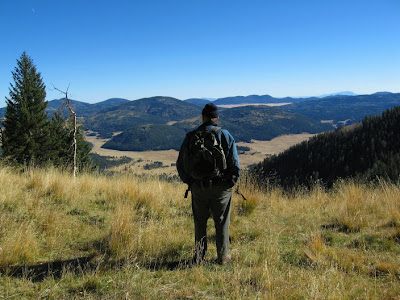 Hiker Overlooking Valle San Antonio from Cerro de la Garita on North Rim
 Late Afternoon on North Rim Logging Road
I have to admit, even though I have complained a lot about not being able to hike wherever I want on the Preserve, I feel sympathy for the difficult and complex task the Preserve has before it. The Valles Caldera Trust has been given by Congress the conflicting goals of sharing the Valles Caldera National Preserve with the public, while yet protecting and preserving the integrity of the land, and all the while working toward financial self-sufficiency by 2015.
If you take the time to read the 2006 Report to Congress, which is a very interesting document and is available on the Valles Caldera National Preserve website, the budget numbers tell a story. In 2006, the Valles Caldera Trust’s revenues earned from all recreation activities were less than 9% of its total expenditures. It’s obvious that since the public is allowed only limited use of the Preserve, the idea being to keep the Preserve from being overrun by swarms of people and overwhelmed by snarls of traffic like at Yosemite, the Grand Canyon, or the Great Smoky Mountains national parks, the Preserve’s fortunes lie elsewhere rather then in allowing more open access to the general public. A few people will get a quality experience on the Preserve and the majority will get no experience at all. Is that fair?
The north rim has a lonely spaciousness that is addictive. Any plans for public access and use that the Trust makes could preserve this rare experience of space-enough not by excluding people but in equitably distributing recreation opportunites throughout the Preserve so as to not overly concentrate activities or vehicles into any one area. The over-concentration of people in scenic hotspots is behind the problems of overcrowding at national parks like the Great Smokey Mountains where the main problem is vehicular traffic--too much of it.
I wonder how many people out there are infected, like I am, with an incredible longing to explore the inner sanctum of the Valles Caldera National Preserve and frustrated that after eight years, the progress is so slow in allowing greater public access?
If you care about the future of the Preserve and your access to it, let me remind you again that in 2008 the Valles Caldera Trust will continue the planning process for visitor use and access on the Valles Caldera National Preserve. Check the Valles Caldera National Preserve for notice of upcoming public meetings and how to submit comments. Please be part of the process. Let the Trust know your concerns.
 Valles Caldera Northwest-North Rim
Click on the map to enlarge it and look at the boundary line between Rio Arriba and Sandoval counties at the top, middle of the map. You'll see that "Cerro de la Garita" appears twice--once south of Rio Arriba county, on the Valles Caldera National Preserve, and once north of Sandoval county, on Santa Fe National Forest land in the northern Jemez Mountains. To access Cerro de la Garita from within the SFNF, take either the northern leg of FR 144 out of Española or FR 100-FR 99 out of Youngsville to intersect FR 144. To access Cerro de la Garita on the VCNP is presently not possible by mere mortals!! You can get close, though, by signing up for the VCNP's La Garita hike. The La Garita hike is located to the east of Cerro de la Garita and gets you on the north rim for spectacular views!
Special thanks to Donald and Dorothy Hoard for their encouragement and help on this project.
Summer

Twin Cabins-Pipeline Road Gate in the Northwest Corner of Valles Caldera National Preserve


 Four Views (above) of the Forests and Meadows of the North Rim
The north rim is so far away from everything. It is heavily treed in places and a morass of logging roads with few views into the caldera. There are crisscrosses of downed timber. It was frankly impossible to start north rim explores before summer because the access road, Forest Road (FR) 144, was covered up high with heavy snows. Despite these deficits, the Valles Caldera north rim will draw you in and draw you back, again and again, because it is an area of peaceful beauty and solitude.
One cautionary note about the Valles Caldera rim--in places where the rim wanders around in the woods, which describes a lot of the north rim, figuring out if you’re really on the rim is not intuitive. I wonder how people like me who have a distorted sense of direction that not even a GPS can compensate for will find their way! Some ideas that have been suggested to help people find the rim trails are marking the route with diamonds like cross-country ski trails, making waypoints of the Valles Caldera Rim Trail for download, and making a dedicated map of the whole route.
 Ring-Fracture Domes with Resurgent Dome Beyond
This photo is a good argument for taking field notes while you are photographing the caldera. That’s Redondo for sure in the background and this is looking into Valle San Antonio but then I’m unsure if I’m seeing all three of the Valles Caldera northwest ring-fracture domes or only two of them. I’ll just give you the line up of domes and their elevations in the northwest corner from east to west: Cerro San Luis,9510’, Cerro Seco, 9931’, and then San Antonio Mountain which has two peaks, 10,908’ and 9988’.
The caldera has a paid, reservation only hike to Cerro Seco. You are allowed 4 short hours to wind around Cerro Seco on old logging roads. It hardly even leaves enough time to go to the top, picnic, and get back on time to catch the van ride back to your vehicle. You really have to hustle to do it and where’s the enjoyment in that?
 Redondo Peeking above Hilton View
The golden grass of late summer and Redondo Peak are seen from Hilton Cabin View which is near the Santa Fe National Forest (SFNF)-VCNP boundary gate above the Hilton Cabin. At one time, the VCNP had a hike to Hilton Cabin and this hillside was the endpoint of the 12 mile roundtrip hike. People groused that the views weren’t worth the distance walked so the VCNP eliminated it. It wasn’t profitable to drive a few people the long distance to the trailhead. That’s sad, because the hike was a wonderful way to become acquainted with the charms of the north rim’s solitude, beauty and isolation. It’s a bad idea to have people’s appreciation of the Valles Caldera National Preserve be driven by the bottom line!
 View from Cerro de la Garita toward Grasslands of North Rim
From the north rim, looking northeast, are the grasslands of Garita Ridge-Hunter’s Point, right, and Cerro de la Garita, left. Polvadera’s bald spot is peeking up above Cerro de la Garita and Tschicoma and the grasslands above Santa Clara Canyon rim are above Garita Ridge-Hunter’s Point. The Valles Caldera is viewer friendly because from most anywhere on the rim you’ll get very satisfying views of other parts of the rim and into the caldera.
 The Sierra de Toledo Is Jam-Packed into the Toledo Embayment
 Looking eastward from the north rim, you can see, clockwise, the grasslands of Garita Ridge-Hunter’s Point, the grasslands on the Santa Clara Canyon rim, Tschicoma, an unnamed peak, Cerro Toledo, Indian Point, and Turkey Ridge, with its upside down Hershey-Kiss bald spot. All those domes in front of Tschicoma are in the Toledo Embayment and are Cerro Toledo Rhyolite domes formed after the Toledo Caldera collapse. Collectively, these domes are called the Sierra de Toledo and form the northeastern rim of the Valles Caldera. The reciprocal conservation easement between Santa Clara Pueblo and the VCNP runs along the crest of the Sierra de Toledo. Although hiking on the VCNP side of the easement is not forbidden by the easement wording, this area is off-limits for now.
 Cerro Seco and San Antonio Mountain
This is looking southwest at the two westernmost ring-fracture domes of the Valles Caldera--Cerro Seco (left) and San Antonio Mountain (right).
The views that can be seen from the grasslands of Cerro de la Garita on the north rim include the Nacimientos, Mt. Taylor, the cliffs below FR144, FR 144 itself, Cerro San Luis, Cerro Seco, San Antonio Mountain, Redondo Border, Redondo, Cerro Santa Rosa, Trasquilar, Cerros del Abrigo, Cerro del Medio, the Sierra de los Valles on the east rim, Rabbit Ridge-Rabbit Mountain-Las Conchas-Los Griegos on the south rim, and Garita Ridge-Hunter’s Point, Cerro Toledo, Indian Point, Turkey Ridge on the north-northeast rim. In short, the views from Cerro de la Garita are spectacular! Of all the rims, the north rim is the highest. In part, this may be because landslides in the geologic past have steepened the north rim, especially above Valle San Antonio, where Cerro de la Garita is located, which has numerous landslide blocks that have come off the north rim wall.
A unique feature of views from Cerro de la Garita is how close the views are of the northern ring-fracture domes and the resurgent dome, Redondo--close enough that you can clearly visualize the ring-fracture encircling the resurgent dome and this leads to greater understanding of the Valles Caldera than just reading about it in a geology treatise or looking at photos! With the Valles Caldera Preserve’s mandate to become financially self sufficient by 2015, a price is put on what is priceless: learning firsthand about this beautiful natural wonder of the world!
 Valles Caldera Northern Moat Rhyolites from Cerro de la Garita--the North Rim Supreme
Looking southeast from Cerro de la Garita, the Valle San Antonio is to the west (right) and Valle Toledo to the east (left). San Antonio Creek flows between the two small domes in the center. Trasquilar is on the north (left) and is an exquisite, miniature, conical dome of Cerro Toledo Rhyolite making it a ring-fracture dome of the Toledo Caldera which predates the Valles Caldera by four hundred thousand years.
On the right of Trasquilar, and looking like a flying saucer, is Santa Rosa, part of the larger Cerro Santa Rosa dome complex that extends behind it in a long, southwestward ridge. To the left of Santa Rosa is Cerros del Abrigo. Cerro del Medio is next to Abrigo but it’s lower and you can only see an arm of it reaching out to divide the Valle Toledo from the Valle de los Posos, of which only a thin smear is visible. Cerros Santa Rosa, Cerros del Abrigo, and Cerro del Media are all ring-fracture domes that rose up around the resurgent dome, Redondo, after the collapse of the Valles Caldera.
This photo also shows the northeast-east (left) and southeast-south (right) Valles Caldera rims. Going around clockwise (left horizon), beginning above Valle Toledo, are the west and east Cerros de los Posos domes on the northeast rim and then on the east rim are Cerro Bonito, Pajarito Mountain (with two peaks), and Cerro Grande (the latter three are part of the Sierra de los Valles that lies west of Los Alamos). Continuing clockwise past Cerro del Medio and Cerros del Abrigo is the southeast-south rim with Scooter Peak, Rabbit Ridge, Rabbit Mountain, and the Paso del Norte area.
 Hiker Overlooking Valle San Antonio from Cerro de la Garita on North Rim
 Late Afternoon on North Rim Logging Road
I have to admit, even though I have complained a lot about not being able to hike wherever I want on the Preserve, I feel sympathy for the difficult and complex task the Preserve has before it. The Valles Caldera Trust has been given by Congress the conflicting goals of sharing the Valles Caldera National Preserve with the public, while yet protecting and preserving the integrity of the land, and all the while working toward financial self-sufficiency by 2015.
If you take the time to read the 2006 Report to Congress, which is a very interesting document and is available on the Valles Caldera National Preserve website
The north rim has a lonely spaciousness that is addictive. Any plans for public access and use that the Trust makes could preserve this rare experience of space-enough not by excluding people but in equitably distributing recreation opportunites throughout the Preserve so as to not overly concentrate activities or vehicles into any one area. The over-concentration of people in scenic hotspots is behind the problems of overcrowding at national parks like the Great Smokey Mountains where the main problem is vehicular traffic--too much of it.
I wonder how many people out there are infected, like I am, with an incredible longing to explore the inner sanctum of the Valles Caldera National Preserve and frustrated that after eight years, the progress is so slow in allowing greater public access?
If you care about the future of the Preserve and your access to it, let me remind you again that in 2008 the Valles Caldera Trust will continue the planning process for visitor use and access on the Valles Caldera National Preserve. Check the Valles Caldera National Preserve
 Valles Caldera Northwest-North Rim
Click on the map to enlarge it and look at the boundary line between Rio Arriba and Sandoval counties at the top, middle of the map. You'll see that "Cerro de la Garita" appears twice--once south of Rio Arriba county, on the Valles Caldera National Preserve, and once north of Sandoval county, on Santa Fe National Forest land in the northern Jemez Mountains. To access Cerro de la Garita from within the SFNF, take either the northern leg of FR 144 out of Española or FR 100-FR 99 out of Youngsville to intersect FR 144. To access Cerro de la Garita on the VCNP is presently not possible by mere mortals!! You can get close, though, by signing up for the VCNP's La Garita hike. The La Garita hike is located to the east of Cerro de la Garita and gets you on the north rim for spectacular views!